Google StreetView was certainly a trail-blazing concept and it has entered the mainstream. But it was not the first service and Google isn’t the first company that had the concept to collect data about the physical world by driving a specially equipped vehicle (with one or more cameras, high performance GPS and other sensors) through space. Decades earlier, the Jet Propulsion Laboratory worked on this concept in order to permit the vehicles landing on the moon (or other spatial bodies) to record their immediate environment. Earthmine is a pioneer not only in the capture of the real world (using designs developed by the JPL) but also to explore business models based on this data sets. What do these have in common? They proved that the ambitious goal of digitally “capturing” the real world in a form that supports navigation through the data afterwards, was possible.
As the technologies developed in these projects have evolved and become more powerful–in every dimension–and competitors have emerged based on other maturing technologies, systems are detecting the physical world at higher and higher resolutions, and the data gathered produce increasingly more accurate models at lower costs.
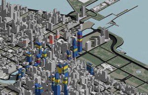
 Instead of “manually” building up a 3D model from a 2D map and/or analog data, urban environments are being scanned, measured and modeled at an amazing speed, and at lower cost than ever before. Fascinating, but to what end?
In the AR-4-Basel project, we seek to make available to AR developers accurate 3D models in order for the digital representation of the real world to serve as the basis for higher performance AR experiences. The concept is that if a developer were able to use the model when designing experiences, or the placement of content, they would have a virtual reality in which to experiment. Then, when in the real world the user’s device with a camera would automatically extract features, such as edges of buildings, roofs, and other stationary attributes of the world, and match those with the features “seen” earlier in the digital model. The digital data would be aligned more accurately and the process of augmenting the world with the desired content would be faster.
In order to determine if this is more than just a concept, I need to find and receive the assistance of 3D city model experts. Here are a few of the sites to which I’ve been in search of such knowledge:
- CityGML web site and articles such as this one by Thomas Kolbe in 2005
- 3D Reality Maps
- CyberCity3D
- Procedural
- SemCity
- Navteq Network for Developers
- GeoSim Cities
- Video and Image Processing Lab on 3D City Models (UC Berkeley)
This process is proving to be time consuming but it might yield some results before another solution to improve AR experience quality emerges!
